A Volumetric Method for Building Complex Models from Range Images
Brian Curless and Marc Levoy
Stanford University
Abstract:
A number of techniques have been developed for reconstructing surfaces
by integrating groups of aligned range images. A desirable set of
properties for such algorithms includes: incremental updating,
representation of directional uncertainty, the ability to fill gaps in
the reconstruction, and robustness in the presence of outliers. Prior
algorithms possess subsets of these properties. In this paper, we
present a volumetric method for integrating range images that
possesses all of these properties.
Our volumetric representation consists of a cumulative weighted signed
distance function. Working with one range image at a time, we first
scan-convert it to a distance function, then combine this with the
data already acquired using a simple additive scheme. To achieve
space efficiency, we employ a run-length encoding of the volume. To
achieve time efficiency, we resample the range image to align with the
voxel grid and traverse the range and voxel scanlines synchronously.
We generate the final manifold by extracting an isosurface from the
volumetric grid. We show that under certain assumptions, this
isosurface is optimal in the least squares sense. To fill gaps in the
model, we tessellate over the boundaries between regions seen to be
empty and regions never observed.
Using this method, we are able to integrate a large number of range
images (as many as 70) yielding seamless, high-detail models of up to
2.6 million triangles.
CR Categories: I.3.5 [Computer Graphics] Computational Geometry
and Object Modeling
Additional keywords: Surface fitting, three-dimensional shape
recovery, range image integration, isosurface extraction
Recent years have witnessed a rise in the availability of fast,
accurate range scanners. These range scanners have provided data for
applications such as medicine, reverse engineering, and digital
film-making. Many of these devices generate range images; i.e.,
they produce depth values on a regular sampling lattice.
Figure 1 illustrates how an optical triangulation
scanner can be used to acquire a range image. By connecting nearest
neighbors with triangular elements, one can construct a range
surface as shown in Figure 1d. Range images are
typically formed by sweeping a 1D or 2D sensor linearly across an
object or circularly around it, and generally do not contain enough
information to reconstruct the entire object being scanned.
Accordingly, we require algorithms that can merge multiple range
images into a single description of the surface. A set of desirable
properties for such a surface reconstruction algorithm includes:
-
Representation of range uncertainty. The data in range images
typically have asymmetric error distributions with primary directions
along sensor lines of sight, as illustrated for optical triangulation
in Figure 1a. The method of range integration
should reflect this fact.
-
Utilization of all range data, including redundant observations
of each object surface. If properly used, this redundancy can reduce
sensor noise.
-
Incremental and order independent updating. Incremental updates
allow us to obtain a reconstruction after each scan or small set of
scans and allow us to choose the next best orientation for scanning.
Order independence is desirable to ensure that results are
not biased by earlier scans. Together, they allow for straightforward
parallelization.
-
Time and space efficiency. Complex objects may require many
range images in order to build a detailed model. The range images and
the model must be represented efficiently and processed quickly to
make the algorithm practical.
-
Robustness. Outliers and systematic range distortions can
create challenging situations for reconstruction algorithms. A robust
algorithm needs to handle these situations without catastrophic
failures such as holes in surfaces and self-intersecting surfaces.
-
No restrictions on topological type. The algorithm should not
assume that the object is of a particular genus. Simplifying
assumptions such as ``the object is homeomorphic to a sphere'' yield
useful results in only a restricted class of problems.
-
Ability to fill holes in the reconstruction. Given a set of
range images that do not completely cover the object, the surface
reconstruction will necessarily be incomplete. For some objects, no
amount of scanning would completely cover the object, because some
surfaces may be inaccessible to the sensor. In these cases, we desire
an algorithm that can automatically fill these holes with plausible
surfaces, yielding a model that is both ``watertight'' and
esthetically pleasing.
In this paper, we present a volumetric method for integrating range
images that possesses all of these properties. In the next section,
we review some previous work in the area of surface reconstruction.
In section 3, we describe the core of our volumetric algorithm. In
section 4, we show how this algorithm can be used to fill gaps in the
reconstruction using knowledge about the emptiness of space. Next, in
section 5, we describe how we implemented our volumetric approach so
as to keep time and space costs reasonable. In section 6, we show the
results of surface reconstruction from many range images of complex
objects. Finally, in section 7 we conclude and discuss limitations and
future directions.
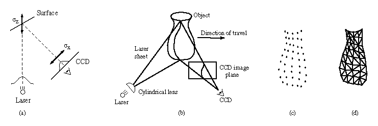
Figure 1:
From optical triangulation to a range surface. (a) In 2D, a narrow
laser beam illuminates a surface, and a linear sensor images the
reflection from an object. The center of the image pulse maps to the
center of the laser, yielding a range value. The uncertainty,
 , in determining the center of the pulse results in range
uncertainty,
, in determining the center of the pulse results in range
uncertainty,  along the laser's line of sight. When using
the spacetime analysis for optical triangulation
[6], the uncertainties run along
the lines of sight of the CCD. (b) In 3D, a laser stripe triangulation
scanner first spreads the laser beam into a sheet of light with a
cylindrical lens. The CCD observes the reflected stripe from which a
depth profile is computed. The object sweeps through the field of
view, yielding a range image. Other scanner configurations rotate the
object to obtain a cylindrical scan or sweep a laser beam or stripe
over a stationary object. (c) A range image obtained from the scanner
in (b) is a collection of points with regular spacing. (d) By
connecting nearest neighbors with triangles, we create a piecewise
linear range surface.
along the laser's line of sight. When using
the spacetime analysis for optical triangulation
[6], the uncertainties run along
the lines of sight of the CCD. (b) In 3D, a laser stripe triangulation
scanner first spreads the laser beam into a sheet of light with a
cylindrical lens. The CCD observes the reflected stripe from which a
depth profile is computed. The object sweeps through the field of
view, yielding a range image. Other scanner configurations rotate the
object to obtain a cylindrical scan or sweep a laser beam or stripe
over a stationary object. (c) A range image obtained from the scanner
in (b) is a collection of points with regular spacing. (d) By
connecting nearest neighbors with triangles, we create a piecewise
linear range surface.
Surface reconstruction from dense range data has been an active area
of research for several decades. The strategies have proceeded along
two basic directions: reconstruction from unorganized points, and
reconstruction that exploits the underlying structure of the acquired
data. These two strategies can be further subdivided according to
whether they operate by reconstructing parametric surfaces or by
reconstructing an implicit function.
A major advantage of the unorganized points algorithms is the fact
that they do not make any prior assumptions about connectivity of
points. In the absence of range images or contours to provide
connectivity cues, these algorithms are the only recourse. Among the
parametric surface approaches, Boissanat
[2] describes a method for Delaunay
triangulation of a set of points in 3-space. Edelsbrunner and
Mücke [9] generalize the notion of
a convex hull to create surfaces called alpha-shapes. Examples of
implicit surface reconstruction include the method of Hoppe, et al
[16] for generating a signed distance
function followed by an isosurface extraction. More recently, Bajaj,
et al [1] used alpha-shapes to construct
a signed distance function to which they fit implicit polynomials.
Although unorganized points algorithms are widely applicable, they
discard useful information such as surface normal and reliability
estimates. As a result, these algorithms are well-behaved in smooth
regions of surfaces, but they are not always robust in regions of high
curvature and in the presence of systematic range distortions and
outliers.
Among the structured data algorithms, several parametric approaches
have been proposed, most of them operating on range images in a
polygonal domain. Soucy and Laurendeau [25]
describe a method using Venn diagrams to identify overlapping data
regions, followed by re-parameterization and merging of regions. Turk
and Levoy [30] devised an incremental
algorithm that updates a reconstruction by eroding redundant geometry,
followed by zippering along the remaining boundaries, and finally a
consensus step that reintroduces the original geometry to establish
final vertex positions. Rutishauser, et al
[24] use errors along the sensor's
lines of sight to establish consensus surface positions followed by a
re-tessellation that incorporates redundant data. These algorithms
typically perform better than unorganized point algorithms, but they
can still fail catastrophically in areas of high curvature, as
exemplified in Figure 8.
Several algorithms have been proposed for integrating structured data
to generate implicit functions. These algorithms can be classified as
to whether voxels are assigned one of two (or three) states or are
samples of a continuous function. Among the discrete-state volumetric
algorithms, Connolly [4] casts rays from a
range image accessed as a quad-tree into a voxel grid stored as an
octree, and generates results for synthetic data. Chien, et al
[3] efficiently generate octree models under
the severe assumption that all views are taken from the directions
corresponding to the 6 faces of a cube. Li and Crebbin
[19] and Tarbox and Gottschlich
[28] also describe methods for
generating binary voxel grids from range images. None of these
methods has been used to generate surfaces. Further, without an
underlying continuous function, there are no mechanism for
representing range uncertainty or for combining overlapping, noisy
range surfaces.
The last category of our taxonomy consists of implicit function
methods that use samples of a continuous function to combine
structured data. Our method falls into this category. Previous
efforts in this area include the work of Grosso, et al
[12], who generate depth maps from stereo and
average them into a volume with occupancy ramps of varying slopes
corresponding to uncertainty measures; they do not, however, perform a
final surface extraction. Succi, et al [26]
create depth maps from stereo and optical flow and integrate them
volumetrically using a straight average. The details of his method
are unclear, but they appear to extract an isosurface at an arbitrary
threshold. In both the Grosso and Succi papers, the range maps are
sparse, the directions of range uncertainty are not characterized,
they use no time or space optimizations, and the final models are of
low resolution. Recently, Hilton, et al [14]
have developed a method similar to ours in that it uses weighted
signed distance functions for merging range images, but it does not
address directions of sensor uncertainty, incremental updating, space
efficiency, and characterization of the whole space for potential hole
filling, all of which we believe are crucial for the success of this
approach.
Other relevant work includes the method of probabilistic occupancy
grids developed by Elfes and Matthies [10].
Their volumetric space is a scalar probability field which they update
using a Bayesian formulation. The results have been used for robot
navigation, but not for surface extraction. A difficulty with this
technique is the fact that the best description of the surface lies at
the peak or ridge of the probability function, and the problem of
ridge-finding is not one with robust solutions
[8]. This is one of our primary motivations for
taking an isosurface approach in the next section: it leverages off of
well-behaved surface extraction algorithms.
The discrete-state implicit function algorithms described above also
have much in common with the methods of extracting volumes from
silhouettes [15] [21]
[23] [27]. The
idea of using backdrops to help carve out the emptiness of space is
one we demonstrate in section 4.
Our algorithm employs a continuous implicit function,  ,
represented by samples. The function we represent is the weighted
signed distance of each point
,
represented by samples. The function we represent is the weighted
signed distance of each point  to the nearest range surface
along the line of sight to the sensor. We construct this function by
combining signed distance functions
to the nearest range surface
along the line of sight to the sensor. We construct this function by
combining signed distance functions  ,
,  ,
...
,
...  and weight functions
  ,
,  , ...
, ...  obtained from range images 1 ... n. Our
combining rules give us for each voxel a cumulative signed distance
function, , and a cumulative weight
obtained from range images 1 ... n. Our
combining rules give us for each voxel a cumulative signed distance
function, , and a cumulative weight  . We
represent these functions on a discrete voxel grid and extract an
isosurface corresponding to
. We
represent these functions on a discrete voxel grid and extract an
isosurface corresponding to  . Under a certain set of
assumptions, this isosurface is optimal in the least squares sense. A
full proof of this optimality is beyond the scope of this paper, but a
sketch appears in appendix A.
. Under a certain set of
assumptions, this isosurface is optimal in the least squares sense. A
full proof of this optimality is beyond the scope of this paper, but a
sketch appears in appendix A.
Figure 2 illustrates the principle of combining
unweighted signed distances for the simple case of two range surfaces
sampled from the same direction. Note that the resulting isosurface
would be the surface created by averaging the two range surfaces along
the sensor's lines of sight. In general, however, weights are
necessary to represent variations in certainty across the range
surfaces. The choice of weights should be specific to the range
scanning technology. For optical triangulation scanners, for example,
Soucy [25] and Turk
[30] make the weight depend on the dot product
between each vertex normal and the viewing direction, reflecting
greater uncertainty when the illumination is at grazing angles to the
surface. Turk also argues that the range data at the boundaries of
the mesh typically have greater uncertainty, requiring more
down-weighting. We adopt these same weighting schemes for our optical
triangulation range data.
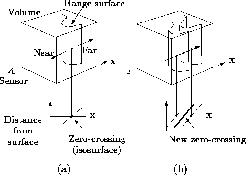
Figure 2: Unweighted signed distance
functions in 3D. (a) A range sensor looking down the x-axis observes
a range image, shown here as a reconstructed range surface. Following
one line of sight down the x-axis, we can generate a signed distance
function as shown. The zero crossing of this function is a point on
the range surface. (b) The range sensor repeats the measurement, but
noise in the range sensing process results in a slightly different
range surface. In general, the second surface would interpenetrate
the first, but we have shown it as an offset from the first surface
for purposes of illustration. Following the same line of sight as
before, we obtain another signed distance function. By summing these
functions, we arrive at a cumulative function with a new zero crossing
positioned midway between the original range measurements.
Figure 3 illustrates the construction and usage of
the signed distance and weight functions in 1D. In
Figure 3a, the sensor is positioned at the origin
looking down the +x axis and has taken two measurements,  and
and
 . The signed distance profiles,
  and
and  may extend
indefinitely in either direction, but the weight functions,
may extend
indefinitely in either direction, but the weight functions,  and
and  , taper off behind the range points for reasons discussed
below.
, taper off behind the range points for reasons discussed
below.
Figure 3b is the weighted combination of the two
profiles. The combination rules are straightforward:


where,  and
and  are the signed distance and
weight functions from the ith range image.
are the signed distance and
weight functions from the ith range image.
Expressed as an incremental calculation, the rules are:


where  and
and  are the cumulative signed
distance and weight functions after integrating the ith range
image.
are the cumulative signed
distance and weight functions after integrating the ith range
image.
In the special case of one dimension, the zero-crossing of the
cumulative function is at a range, R given by:

i.e., a weighted combination of the acquired range values, which is
what one would expect for a least squares minimization.
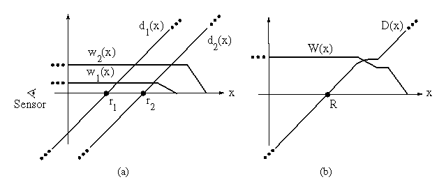
Figure 3: Signed
distance and weight functions in one dimension. (a) The
sensor looks down the x-axis and takes two measurements, and
. and are the signed distance profiles, and
and are the weight functions. In 1D, we might
expect two sensor measurements to have the same weight magnitudes, but
we have shown them to be of different magnitude here to illustrate how
the profiles combine in the general case. (b) D(x) is a
weighted combination of and , and W(x) is the sum
of the weight functions. Given this formulation, the zero-crossing,
R, becomes the weighted combination of and and
represents our best guess of the location of the surface. In
practice, we truncate the distance ramps and weights to the vicinity
of the range points.
In principle, the distance and weighting functions should extend
indefinitely in either direction. However, to prevent surfaces on
opposite sides of the object from interfering with each other, we
force the weighting function to taper off behind the surface. There
is a trade-off involved in choosing where the weight function tapers
off. It should persist far enough behind the surface to ensure that
all distance ramps will contribute in the vicinity of the final zero
crossing, but, it should also be as narrow as possible to avoid
influencing surfaces on the other side. To meet these requirements,
we force the weights to fall off at a distance equal to half the
maximum uncertainty interval of the range measurements. Similarly,
the signed distance and weight functions need not extend far in front
of the surface. Restricting the functions to the vicinity of the
surface yields a more compact representation and reduces the
computational expense of updating the volume.
In two and three dimensions, the range measurements correspond to
curves or surfaces with weight functions, and the signed distance
ramps have directions that are consistent with the primary directions
of sensor uncertainty. The uncertainties that apply to range image
integration include errors in alignment between meshes as well as
errors inherent in the scanning technology. A number of algorithms
for aligning sets of range images have been explored and shown to
yield excellent results
[11][30]. The
remaining error lies in the scanner itself. For optical triangulation
scanners, for example, this error has been shown to be ellipsoidal
about the range points, with the major axis of the ellipse aligned
with the lines of sight of the laser
[13][24].
Figure 4 illustrates the two-dimensional case for
a range curve derived from a single scan containing a row of range
samples. In practice, we use a fixed point representation for the
signed distance function, which bounds the values to lie between
 and
and  as shown in the figure. The values of
and must be negative and positive, respectively,
as they are on opposite sides of a signed distance zero-crossing.
as shown in the figure. The values of
and must be negative and positive, respectively,
as they are on opposite sides of a signed distance zero-crossing.
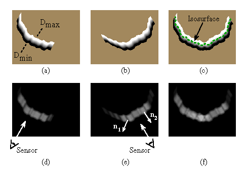
Figure 4: Combination of signed distance and weight functions in two
dimensions. (a) and (d) are the signed distance and weight functions,
respectively, generated for a range image viewed from the sensor line
of sight shown in (d). The signed distance functions are chosen to
vary between and , as shown in (a). The weighting
falls off with increasing obliquity to the sensor and at the edges of
the meshes as indicated by the darker regions in (e). The normals,
 and
and  shown in (e), are oriented at a grazing
angle and facing the sensor, respectively. Note how the weighting is
lower (darker) for the grazing normal. (b) and (e) are the signed
distance and weight functions for a range image of the same object
taken at a 60 degree rotation. (c) is the signed distance function
corresponding to the per voxel weighted combination of
(a) and (b) constructed using equations 3 and 4. (f) is the sum of
the weights at each voxel, . The dotted green curve in
(c) is the isosurface that represents our current estimate of the
shape of the object.
shown in (e), are oriented at a grazing
angle and facing the sensor, respectively. Note how the weighting is
lower (darker) for the grazing normal. (b) and (e) are the signed
distance and weight functions for a range image of the same object
taken at a 60 degree rotation. (c) is the signed distance function
corresponding to the per voxel weighted combination of
(a) and (b) constructed using equations 3 and 4. (f) is the sum of
the weights at each voxel, . The dotted green curve in
(c) is the isosurface that represents our current estimate of the
shape of the object.
For three dimensions, we can summarize the whole algorithm as follows.
First, we set all voxel weights to zero, so that new data will
overwrite the initial grid values. Next, we tessellate each range
image by constructing triangles from nearest neighbors on the sampled
lattice. We avoid tessellating over step discontinuities (cliffs in
the range map) by discarding triangles with edge lengths that exceed a
threshold. We must also compute a weight at each vertex as described
above.
Once a range image has been converted to a triangle mesh with a weight
at each vertex, we can update the voxel grid. The signed distance
contribution is computed by casting a ray from the sensor through each
voxel near the range surface and then intersecting it with the
triangle mesh, as shown in figure 5. The weight is
computed by linearly interpolating the weights stored at the
intersection triangle's vertices. Having determined the signed
distance and weight we can apply the update formulae described in
equations 3 and 4.
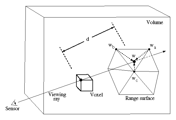
Figure 5: Sampling the range surface to update the volume. We compute the
weight, w, and signed distance, d, needed to update the voxel by
casting a ray from the sensor, through the voxel onto the range
surface. We obtain the weight, w, by linearly interpolating the
weights (  ,
,  , and
, and  ) stored at neighboring range
vertices. Note that for a translating sensor (like our Cyberware
scanner), the sensor point is different for each column of range
points.
) stored at neighboring range
vertices. Note that for a translating sensor (like our Cyberware
scanner), the sensor point is different for each column of range
points.
At any point during the merging of the range images, we can extract
the zero-crossing isosurface from the volumetric grid. We restrict
this extraction procedure to skip samples with zero weight, generating
triangles only in the regions of observed data. We will relax this
restriction in the next section.
The algorithm described in the previous section is designed to
reconstruct the observed portions of the surface. Unseen portions of
the surface will appear as holes in the reconstruction. While this
result is an accurate representation of the known surface, the holes
are esthetically unsatisfying and can present a stumbling block to
follow-on algorithms that expect continuous meshes. In
[17], for example, the authors describe a
method for parameterizing patches that entails generating evenly
spaced grid lines by walking across the edges of a mesh. Gaps in the
mesh prevent the algorithm from creating a fair parameterization. As
another example, rapid prototyping technologies such as
stereolithography typically require a ``watertight'' model in order to
construct a solid replica [7].
One option for filling holes is to operate on the reconstructed mesh.
If the regions of the mesh near each hole are very nearly planar, then
this approach works well. However, holes in the meshes can be (and
frequently are) highly non-planar and may even require connections
between unconnected components. Instead, we offer a hole filling
approach that operates on our volume, which contains more information
than the reconstructed mesh.
The key to our algorithm lies in classifying all points in the volume
as being in one of three states: unseen, empty, or near the surface.
Holes in the surface are indicated by frontiers between unseen regions
and empty regions (see Figure 6). Surfaces placed
at these frontiers offer a plausible way to plug these holes (dotted
in Figure 6). Obtaining this classification and
generating these hole fillers leads to a straightforward extension of
the algorithm described in the previous section:
-
Initialize the voxel space to the ``unseen'' state.
-
Update the voxels near the surface as described in the previous
section. As before, these voxels take on continuous signed distance
and weight values.
-
Follow the lines of sight back from the observed surface and mark the
corresponding voxels as ``empty''. We refer to this step as
space carving.
-
Perform an isosurface extraction at the zero-crossing of the signed
distance function. Additionally, extract a surface between regions
seen to be empty and regions that remain unseen.
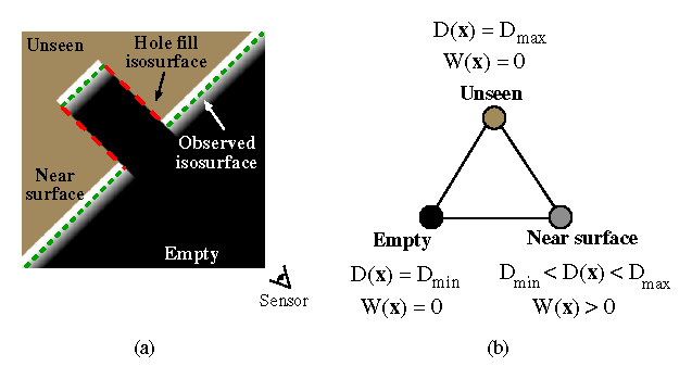
Figure 6: Volumetric grid with space carving and hole filling. (a) The regions
in front of the surface are seen as empty, regions in the vicinity of
the surface ramp through the zero-crossing, while regions behind
remain unseen. The green (dashed) segments are the isosurfaces
generated near the observed surface, while the red (dotted) segments
are hole fillers, generated by tessellating over the transition from
empty to unseen. In (b), we identify the three extremal voxel states
with their corresponding function values.
In practice, we represent the unseen and empty states using the
function and weight fields stored on the voxel lattice. We represent
the unseen state with the function values  ,
,
 and the empty state with the function values
  , , as shown in
Figure 6b. The key advantage of this representation
is that we can use the same isosurface extraction algorithm we used in
the previous section without the restriction on interpolating voxels
of zero weight. This extraction finds both the signed distance and
hole fill isosurfaces and connects them naturally where they meet,
i.e., at the corners in Figure 6a where the dotted
red line meets the dashed green line. Note that the triangles that
arise from interpolations across voxels of zero weight are distinct
from the others: they are hole fillers. We take advantage of this
distinction when smoothing surfaces as described below.
, , as shown in
Figure 6b. The key advantage of this representation
is that we can use the same isosurface extraction algorithm we used in
the previous section without the restriction on interpolating voxels
of zero weight. This extraction finds both the signed distance and
hole fill isosurfaces and connects them naturally where they meet,
i.e., at the corners in Figure 6a where the dotted
red line meets the dashed green line. Note that the triangles that
arise from interpolations across voxels of zero weight are distinct
from the others: they are hole fillers. We take advantage of this
distinction when smoothing surfaces as described below.
Figure 6 illustrates the method for a single range
image, and provides a diagram for the three-state classification
scheme. The hole filler isosurfaces are ``false'' in that they are
not representative of the observed surface, but they do derive from
observed data. In particular, they correspond to a boundary that
confines where the surface could plausibly exist. In practice, we
find that many of these hole filler surfaces are generated in crevices
that are hard for the sensor to reach.
Because the transition between unseen and empty is discontinuous and
hole fill triangles are generated as an isosurface between these
binary states, with no smooth transition, we generally observe
aliasing artifacts in these areas. These artifacts can be eliminated
by prefiltering the transition region before sampling on the voxel
lattice using straightforward methods such as analytic filtering or
super-sampling and averaging down. In practice, we have obtained
satisfactory results by applying another technique: post-filtering the
mesh after reconstruction using weighted averages of nearest vertex
neighbors as described in
[29]. The effect of this filtering step is
to blur the hole fill surface. Since we know which triangles
correspond to hole fillers, we need only concentrate the surface
filtering on the these portions of the mesh. This localized filtering
preserves the detail in the observed surface reconstruction. To
achieve a smooth blend between filtered hole fill vertices and the
neighboring ``real'' surface, we allow the filter weights to extend
beyond and taper off into the vicinity of the hole fill boundaries.
We have just seen how ``space carving'' is a useful operation: it
tells us much about the structure of free space, allowing us to fill
holes in an intelligent way. However, our algorithm only carves back
from observed surfaces. There are numerous situations where more
carving would be useful. For example, the interior walls of a hollow
cylinder may elude digitization, but by seeing through the hollow
portion of the cylinder to a surface placed behind it, we can better
approximate its geometry. We can extend the carving paradigm to cover
these situations by placing such a backdrop behind the surfaces being
scanned. By placing the backdrop outside of the voxel grid, we
utilize it purely for carving space without introducing its geometry
into the model.
The examples in this paper were acquired using a Cyberware 3030 MS
laser stripe optical triangulation scanner.
Figure 1b illustrates the scanning geometry: an
object translates through a plane of laser light while the reflections
are triangulated into depth profiles through a CCD camera positioned
off axis. To improve the quality of the data, we apply the method of
spacetime analysis as described in
[6]. The benefits of this
analysis include reduced range noise, greater immunity to reflectance
changes, and less artifacts near range discontinuities.
When using traditional triangulation analysis implemented in hardware
in our Cyberware scanner, the uncertainty in triangulation for our
system follows the lines of sight of the expanding laser beam. When
using the spacetime analysis, however, the uncertainty follows the
lines of sight of the camera. The results described in section 6 of
this paper were obtained with one or the other triangulation method.
In each case, we adhere to the appropriate lines of sight when laying
down signed distance and weight functions.
The creation of detailed, complex models requires a large amount of
input data to be merged into high resolution voxel grids. The
examples in the next section include models generated from as many as
70 scans containing up to 12 million input vertices with volumetric
grids ranging in size up to 160 million voxels. Clearly, time and
space optimizations are critical for merging this data and managing
these grids.
The core data structure is a run-length encoded (RLE) volume with
three run types: empty, unseen, and varying. The varying fields are
stored as a stream of varying data, rather than runs of constant
value. Typical memory savings vary from 10:1 to 20:1. In fact, the
space required to represent one of these voxel grids is usually
less than the memory required to represent the final mesh as a list
of vertices and triangle indices.
Updating the volume from a range image may be likened to inverse
volume rendering: instead of reading from a volume and writing to an
image, we read from a range image and write to a volume. As a result,
we leverage off of a successful idea from the volume rendering
community: for best memory system performance, stream through the
volume and the image simultaneously in scanline order
[18]. In general, however, the
scanlines of a range image are not aligned with the scanlines of the
voxel grid, as shown in Figure 7a. By suitably
resampling the range image, we obtain the desired alignment
(Figure 7b). The resampling process consists of a
depth rendering of the range surface using the viewing
transformation specific to the lines of sight of the range sensor and
using an image plane oriented to align with the voxel grid. We assign
the weights as vertex ``colors'' to be linearly interpolated during
the rendering step, an approach equivalent to Gouraud shading of
triangle colors.
To merge the range data into the voxel grid, we stream through the
voxel scanlines in order while stepping through the corresponding
scanlines in the resampled range image. We map each voxel scanline to
the correct portion of the range scanline as depicted in
Figure 7d, and we resample the range data to yield
a distance from the range surface. Using the combination rules given
by equations 3 and
4, we update the run-length encoded
structure. To preserve the linear memory structure of the RLE volume
(and thus avoid using linked lists of runs scattered through the
memory space), we read the voxel scanlines from the current volume and
write the updated scanlines to a second RLE volume; i.e., we
double-buffer the voxel grid. Note that depending on the scanner
geometry, the mapping from voxels to range image pixels may not be
linear, in which case care must be taken to resample appropriately
[5].
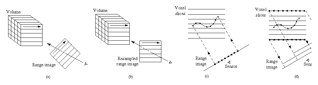
Figure 7: Range image resampling and scanline order voxel updates. (a) Range
image scanlines are not in general oriented to allow for coherently
streaming through voxel and range scanlines. (b) By resampling the
range image, we can obtain the desired range scanline orientation.
(c) Casting rays from the pixels on the range image means cutting
across scanlines of the voxel grid, resulting in poor memory
performance. (d) Instead, we run along scanlines of voxels, mapping
them to the correct positions on the resampled range image.
For the case of merging range data only in the vicinity of the surface,
we try to avoid processing voxels distant from the surface. To that
end, we construct a binary tree of minimum and maximum depths for
every adjacent pair of resampled range image scanlines. Before
processing each voxel scanline, we query the binary tree to decide
which voxels, if any, are near the range surface. In this way, only
relevant pieces of the scanline are processed. In a similar fashion,
the space carving steps can be designed to avoid processing voxels
that are not seen to be empty for a given range image. The resulting
speed-ups from the binary tree are typically a factor of 15 without
carving, and a factor of 5 with carving. We did not implement a
brute-force volume update method, however we would expect the overall
algorithm described here would be much faster by comparison.
To generate our final surfaces, we employ a Marching Cubes algorithm
[20] with a lookup table that resolves
ambiguous cases [22]. To reduce
computational costs, we only process voxels that have varying data or
are at the boundary between empty and unseen.
We show results for a number of objects designed to explore the
robustness of our algorithm, its ability to fill gaps in the
reconstruction, and its attainable level of detail. To explore
robustness, we scanned a thin drill bit using the
traditional method of optical triangulation. Due to the false edge
extensions inherent in data from triangulation scanners
[6], this particular object
poses a formidable challenge, yet the volumetric method behaves
robustly where the zippering method [30] fails
catastrophically. The dragon sequence in Figure 9
demonstrates the effectiveness of carving space for hole filling. The
use of a backdrop here is particularly effective in filling the gaps
in the model. Note that we do not use the backdrop at all times, in
part because the range images are much denser and more expensive to
process, and also because the backdrop tends to obstruct the path of
the object when automatically repositioning it with our motion control
platform. Finally, the ``Happy Buddha'' sequence in
Figure 10 shows that our method can be used to
generate very detailed, hole-free models suitable for rendering and
rapid manufacturing.
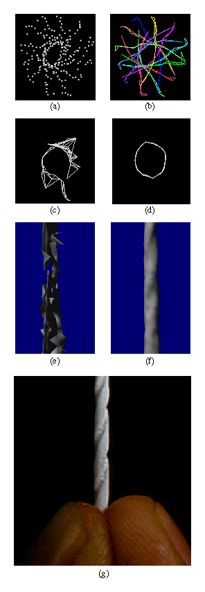
Figure 8: Merging range images of a drill bit. We scanned a 1.6 mm drill bit
from 12 orientations at a 30 degree spacing using traditional optical
triangulation methods. Illustrations (a) - (d) each show a plan (top)
view of a slice taken through the range data and two reconstructions.
(a) The range data shown as unorganized points: algorithms that
operate on this form of data would likely have difficulty deriving the
correct surface. (b) The range data shown as a set of wire frame
tessellations of the range data: the false edge extensions pose a
challenge to both polygon and volumetric methods. (c) A slice through
the reconstructed surface generated by a polygon method: the zippering
algorithm of Turk [31]. (d) A slice through the reconstructed surface
generated by the volumetric method described in this paper. (e) A
rendering of the zippered surface. (f) A rendering of the
volumetrically generated surface. Note the catastrophic failure of
the zippering algorithm. The volumetric method, however, produces a
watertight model. (g) A photograph of the original drill bit. The
drill bit was painted white for scanning.
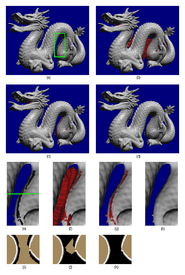
Figure 9: Reconstruction of a dragon. Illustrations (a) - (d) are full views
of the dragon. Illustrations (e) - (h) are magnified views of the
section highlighted by the green box in (a). Regions shown in red
correspond to hole fill triangles. Illustrations (i) - (k) are slices
through the corresponding volumetric grids at the level indicated by
the green line in (e). (a)(e)(i) Reconstruction from 61 range images
without space carving and hole filling. The magnified rendering
highlights the holes in the belly. The slice through the volumetric
grid shows how the signed distance ramps are maintained close to the
surface. The gap in the ramps leads to a hole in the reconstruction.
(b)(f)(j) Reconstruction with space carving and hole filling using the
same data as in (a). While some holes are filled in a reasonable
manner, some large regions of space are left untouched and create
extraneous tessellations. The slice through the volumetric grid
reveals that the isosurface between the unseen (brown) and empty
(black) regions will be connected to the isosurface extracted from the
distance ramps, making it part of the connected component of the
dragon body and leaving us with a substantial number of false
surfaces. (c)(g)(k) Reconstruction with 10 additional range images
using ``backdrop'' surfaces to effect more carving. Notice how the
extraneous hole fill triangles nearly vanish. The volumetric slice
shows how we have managed to empty out the space near the belly. The
bumpiness along the hole fill regions of the belly in (g) corresponds
to aliasing artifacts from tessellating over the discontinuous
transition between unseen and empty regions. (d)(h) Reconstruction as
in (c)(g) with filtering of the hole fill portions of the mesh. The
filtering operation blurs out the aliasing artifacts in the hole fill
regions while preserving the detail in the rest of the model. Careful
examination of (h) reveals a faint ridge in the vicinity of the
smoothed hole fill. This ridge is actual geometry present in all of
the renderings, (e)-(h). The final model contains 1.8 million
polygons and is watertight.
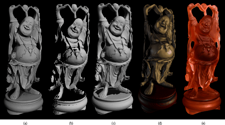
Figure 10: Reconstruction and 3D hardcopy of the ``Happy Buddha''. The original
is a plastic and rosewood statuette that stands 20 cm tall. Note that
the camera parameters for each of these images is different, creating
a slightly different perspective in each case. (a) Photograph of the
original after spray painting it matte gray to simplify scanning. (b)
Gouraud-shaded rendering of one range image of the statuette. Scans
were acquired using a Cyberware scanner, modified to permit spacetime
triangulation [6]. This figure illustrates the limited and fragmentary
nature of the information available from a single range image. (c)
Gouraud-shaded rendering of the 2.4 million polygon mesh after merging
48 scans, but before hole-filling. Notice that the reconstructed mesh
has at least as much detail as the single range image, but is less
noisy; this is most apparent around the belly. The hole in the base
of the model corresponds to regions that were not observed directly by
the range sensor. (d) RenderMan rendering of an 800,000 polygon
decimated version of the hole-filled and filtered mesh built from 58
scans. By placing a backdrop behind the model and taking 10
additional scans, we were able to see through the space between the
base and the Buddha's garments, allowing us to carve space and fill
the holes in the base. (e) Photograph of a hardcopy of the 3D model,
manufactured by 3D Systems, Inc., using stereolithography. The
computer model was sliced into 500 layers, 150 microns apart, and the
hardcopy was built up layer by layer by selectively hardening a liquid
resin. The process took about 10 hours. Afterwards, the model was
sanded and bead-blasted to remove the stair-step artifacts that arise
during layered manufacturing.
Statistics for the reconstruction of the dragon and Buddha models
appear in Figure 11. With the optimizations
described in the previous section, we were able to reconstruct the
observed portions of the surfaces in under an hour on a 250 MHz MIPS
R4400 processor. The space carving and hole filling algorithm is not
completely optimized, but the execution times are still in the range
of 3-5 hours, less than the time spent acquiring and registering the
range images. For both models, the RMS distance between points in
the original range images and points on the reconstructed surfaces is
approximately 0.1 mm. This figure is roughly the same as the accuracy
of the scanning technology, indicating a nearly optimal surface
reconstruction.
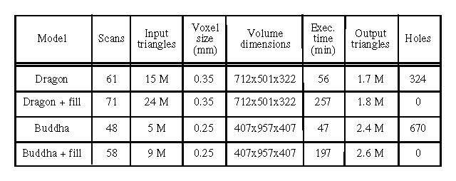
Figure 11: Statistics for the
reconstruction of the dragon and Buddha models, with and without space
carving.
We have described a new algorithm for volumetric integration of range
images, leading to a surface reconstruction without holes. The
algorithm has a number of desirable properties, including the
representation of directional sensor uncertainty, incremental and
order independent updating, robustness in the presence of sensor
errors, and the ability to fill gaps in the reconstruction by carving
space. Our use of a run-length encoded representation of the voxel
grid and synchronized processing of voxel and resampled range image
scanlines make the algorithm efficient. This in turn allows us to
acquire and integrate a large number of range images. In particular,
we demonstrate the ability to integrate up to 70 scans into a high
resolution voxel grid to generate million polygon models in a few
hours. These models are free of holes, making them suitable for
surface fitting, rapid prototyping, and rendering.
There are a number of limitations that prevent us from generating
models from an arbitrary object. Some of these limitations arise from
the algorithm while others arise from the limitations of the scanning
technology. Among the algorithmic limitations, our method has
difficulty bridging sharp corners if no scan spans both surfaces
meeting at the corner. This is less of a problem when applying our
hole-filling algorithm, but we are also exploring methods that will
work without hole filling. Thin surfaces are also problematic. As
described in section 3, the influences of observed surfaces extend
behind their estimated positions for each range image and can
interfere with distance functions originating from scans of the
opposite side of a thin surface. In this respect, the apexes of sharp
corners also behave like thin surfaces. While we have limited this
influence as much as possible, it still places a lower limit on the
thickness of surface that we can reliably reconstruct without causing
artifacts such as thickening of surfaces or rounding of sharp corners.
We are currently working to lift this restriction by considering the
estimated normals of surfaces.
Other limitations arise from the scanning technologies themselves.
Optical methods such as the one we use in this paper can only provide
data for external surfaces; internal cavities are not seen. Further,
very complicated objects may require an enormous amount of scanning to
cover the surface. Optical triangulation scanning has the additional
problem that both the laser and the sensor must observe each point on
the surface, further restricting the class of objects that can be
scanned completely. The reflectance properties of objects are also a
factor. Optical methods generally operate by casting light onto an
object, but shiny surfaces can deflect this illumination, dark objects
can absorb it, and bright surfaces can lead to interreflections. To
minimize these effects, we often paint our objects with a flat, gray
paint.
Straightforward extensions to our algorithm include improving the
execution time of the space carving portion of the algorithm and
demonstrating parallelization of the whole algorithm. In addition,
more aggressive space carving may be possible by making inferences
about sensor lines of sight that return no range data. In the future,
we hope to apply our methods to other scanning technologies and to
large scale objects such as terrain and architectural scenes.
We would like to thank Phil Lacroute for his many helpful suggestions
in designing the volumetric algorithms. Afra Zomorodian wrote the
scripting interface for scanning automation. Homan Igehy wrote the
fast scan conversion code, which we used for range image resampling.
Thanks to Bill Lorensen for his marching cubes tables and mesh
decimation software, and for getting the 3D hardcopy made. Matt Pharr
did the accessibility shading used to render the color Buddha, and Pat
Hanrahan and Julie Dorsey made helpful suggestions for RenderMan
tricks and lighting models. Thanks also to David Addleman and George
Dabrowski of Cyberware for their help and for the use of their
scanner. This work was supported by the National Science Foundation
under contract CCR-9157767 and Interval Research Corporation.
References
- 1
-
C.L. Bajaj, F. Bernardini, and G. Xu.
Automatic reconstruction of surfaces and scalar fields from 3D
scans.
In Proceedings of SIGGRAPH '95 (Los Angeles, CA, Aug. 6-11,
1995), pages 109-118. ACM Press, August 1995.
- 2
-
J.-D. Boissonnat.
Geometric structures for three-dimensional shape representation.
ACM Transactions on Graphics, 3(4):266-286, October 1984.
- 3
-
C.H. Chien, Y.B. Sim, and J.K. Aggarwal.
Generation of volume/surface octree from range data.
In The Computer Society Conference on Computer Vision and
Pattern Recognition, pages 254-60, June 1988.
- 4
-
C. I. Connolly.
Cumulative generation of octree models from range data.
In Proceedings, Intl. Conf. Robotics, pages 25-32, March 1984.
- 5
-
B. Curless.
Better optical triangulation and volumetric reconstruction of
complex models from range images.
PhD thesis, Stanford University, 1996.
- 6
-
B. Curless and M. Levoy.
Better optical triangulation through spacetime analysis.
In Proceedings of IEEE International Conference on Computer
Vision, pages 987-994, June 1995.
- 7
-
A. Dolenc.
Software tools for rapid prototyping technologies in manufacturing.
Acta Polytechnica Scandinavica: Mathematics and Computer Science
Series, Ma62:1-111, 1993.
- 8
-
D. Eberly, R. Gardner, B. Morse, S. Pizer, and C. Scharlach.
Ridges for image analysis.
Journal of Mathematical Imaging and Vision, 4(4):353-373, Dec
1994.
- 9
-
H. Edelsbrunner and E.P. Mücke.
Three-dimensional alpha shapes.
In Workshop on Volume Visualization, pages 75-105, October
1992.
- 10
-
A. Elfes and L. Matthies.
Sensor integration for robot navigation: combining sonar and range
data in a grid-based representation.
In Proceedings of the 26th IEEE Conference on Decision and
Control, pages 1802-1807, December 1987.
- 11
-
H. Gagnon, M. Soucy, R. Bergevin, and D. Laurendeau.
Registration of multiple range views for automatic 3-D model
building.
In Proceedings 1994 IEEE Computer Society Conference on Computer
Vision and Pattern Recognition, pages 581-586, June 1994.
- 12
-
E. Grosso, G. Sandini, and C. Frigato.
Extraction of 3D information and volumetric uncertainty from
multiple stereo images.
In Proceedings of the 8th European Conference on Artificial
Intelligence, pages 683-688, August 1988.
- 13
-
P. Hebert, D. Laurendeau, and D. Poussart.
Scene reconstruction and description: geometric primitive extraction
from multiple viewed scattered data.
In Proceedings of IEEE Conference on Computer Vision and Pattern
Recognition, pages 286-292, June 1993.
- 14
-
A. Hilton, A.J. Toddart, J. Illingworth, and T. Windeatt.
Reliable surface reconstruction from multiple range images.
In Fourth European Conference on Computer Vision, volume I,
pages 117-126, April 1996.
- 15
-
Tsai-Hong Hong and M. O. Shneier.
Describing a robot's workspace using a sequence of views from a
moving camera.
IEEE Transactions on Pattern Analysis and Machine Intelligence,
7(6):721-726, November 1985.
- 16
-
H. Hoppe, T. DeRose, T. Duchamp, J. McDonald, and W. Stuetzle.
Surface reconstruction from unorganized points.
In Computer Graphics (SIGGRAPH '92 Proceedings), volume 26,
pages 71-78, July 1992.
- 17
-
V. Krishnamurthy and M. Levoy.
Fitting smooth surfaces to dense polygon meshes.
In these proceedings.
- 18
-
P. Lacroute and M. Levoy.
Fast volume rendering using a shear-warp factorization of the viewing
transformation.
In Proceedings of SIGGRAPH '94 (Orlando, FL, July 24-29, 1994),
pages 451-458. ACM Press, July 1994.
- 19
-
A. Li and G. Crebbin.
Octree encoding of objects from range images.
Pattern Recognition, 27(5):727-739, May 1994.
- 20
-
W.E. Lorensen and H. E. Cline.
Marching cubes: A high resolution 3D surface construction
algorithm.
In Computer Graphics (SIGGRAPH '87 Proceedings), volume 21,
pages 163-169, July 1987.
- 21
-
W.N. Martin and J.K. Aggarwal.
Volumetric descriptions of objects from multiple views.
IEEE Transactions on Pattern Analysis and Machine Intelligence,
5(2):150-158, March 1983.
- 22
-
C. Montani, R. Scateni, and R. Scopigno.
A modified look-up table for implicit disambiguation of marching
cubes.
Visual Computer, 10(6):353-355, 1994.
- 23
-
M. Potmesil.
Generating octree models of 3D objects from their silhouettes in a
sequence of images.
Computer Vision, Graphics, and Image Processing, 40(1):1-29,
October 1987.
- 24
-
M. Rutishauser, M. Stricker, and M. Trobina.
Merging range images of arbitrarily shaped objects.
In Proceedings 1994 IEEE Computer Society Conference on Computer
Vision and Pattern Recognition, pages 573-580, June 1994.
- 25
-
M. Soucy and D. Laurendeau.
A general surface approach to the integration of a set of range
views.
IEEE Transactions on Pattern Analysis and Machine Intelligence,
17(4):344-358, April 1995.
- 26
-
G. Succi, G. Sandini, E Grosso, and M. Tistarelli.
3D feature extraction from sequences of range data.
In Robotics Research. Fifth International Symposium, pages
117-127, August 1990.
- 27
-
R. Szeliski.
Rapid octree construction from image sequences.
CVGIP: Image Understanding, 58(1):23-32, July 1993.
- 28
-
G.H Tarbox and S.N. Gottschlich.
IVIS: An integrated volumetric inspection system.
In Proceedings of the 1994 Second CAD-Based Vision Workshop,
pages 220-227, February 1994.
- 29
-
G. Taubin.
A signal processing approach to fair surface design.
In Proceedings of SIGGRAPH '95 (Los Angeles, CA, Aug. 6-11,
1995), pages 351-358. ACM Press, August 1995.
- 30
-
G. Turk and M. Levoy.
Zippered polygon meshes from range images.
In Proceedings of SIGGRAPH '94 (Orlando, FL, July 24-29, 1994),
pages 311-318. ACM Press, July 1994.
- 31
-
Robert Weinstock.
The Calculus of Variations, with Applications to Physics and
Engineering.
Dover Publications, 1974.
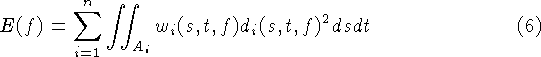
It is possible to show that the isosurface of the weighted signed
distance function is equivalent to a least squares minimization of
squared distances between points on the range surfaces and points on
the desired reconstruction. The key assumptions are that the range
sensor is orthographic and that the range errors are independently
distributed along sensor lines of sight. A full proof is beyond the
scope of this paper, but we provide a sketch here. See
[5] for details.
Consider a region, R, on the desired surface, f, which is observed
by n range images. We define the error between an observed range
surface and a possible reconstructed surface as the integral of the
weighted squared distances between points on the range surface and the
reconstructed surface. These distances are taken along the lines of
sight of the sensor, commensurate with the predominant directions of
uncertainty (see Figure 12). The total error is the
sum of the integrals for the n range images:
where each (s, t) corresponds to a particular sensor line of sight
for each range image,  is the domain of integration for the
i'th range image, and
is the domain of integration for the
i'th range image, and  and
and  are the
weights and signed distances taken along the i'th range image's lines
of sight.
are the
weights and signed distances taken along the i'th range image's lines
of sight.
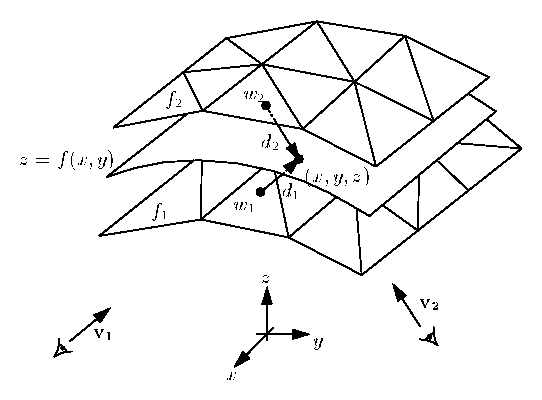
Figure 12: Two range surfaces,  and
and  , are tessellated range images
acquired from directions
, are tessellated range images
acquired from directions  and
and  . The possible range surface,
z = f(x,y), is evaluated in terms of the weighted squared distances
to points on the range surfaces taken along the lines of sight to the
sensor. A point, (x,y,z), is shown here being evaluated to find its
corresponding signed distances,
. The possible range surface,
z = f(x,y), is evaluated in terms of the weighted squared distances
to points on the range surfaces taken along the lines of sight to the
sensor. A point, (x,y,z), is shown here being evaluated to find its
corresponding signed distances,  and
and  , and weights,
  and
and  .
.
Now, consider a canonical domain, A, on a parameter plane, (x,y),
over which R is a function z = f(x,y). The total error can be
re-written as an integration over the canonical domain:

where  is the sensing direction of the i'th range image,
and the weights and distances are evaluated at each point, (x,y,z),
by first mapping them to the lines of sight of the corresponding range
image. The dot product represents a correction term that relates
differential areas in A to differential areas in . Applying
the calculus of variations
[31], we can construct a partial differential
equation for the z that minimizes this integral. Solving this
equation we arrive at the following relation:
is the sensing direction of the i'th range image,
and the weights and distances are evaluated at each point, (x,y,z),
by first mapping them to the lines of sight of the corresponding range
image. The dot product represents a correction term that relates
differential areas in A to differential areas in . Applying
the calculus of variations
[31], we can construct a partial differential
equation for the z that minimizes this integral. Solving this
equation we arrive at the following relation:
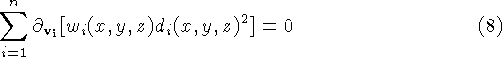
where  is the directional derivative along . Since the weight associated with a line of sight does not vary
along that line of sight, and the signed distance has a derivative of
unity along the line of sight, we can simplify this equation to:
is the directional derivative along . Since the weight associated with a line of sight does not vary
along that line of sight, and the signed distance has a derivative of
unity along the line of sight, we can simplify this equation to:
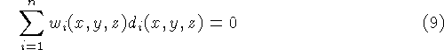
This weighted sum of signed distances is the same as what we compute
in equations 1 and 2, without the
division by the sum of the weights. Since the this divisor is always
positive, the isosurface we extract in section 3 is exactly the least
squares minimizing surface described here.
A Volumetric Method for Building Complex Models from Range Images
This document was generated using the LaTeX2HTML translator Version 96.1 (Feb 5, 1996) Copyright © 1993, 1994, 1995, 1996, Nikos Drakos, Computer Based Learning Unit, University of Leeds.
The command line arguments were:
latex2html -dir /usr/tmp/volrange -show_section_numbers -split 0 paper.tex.
The translation was initiated by Brian Curless on Sun Sep 8 11:02:22 PDT 1996