Descent: 0 feet (0 m)
Description:
Summit Springs is a dead-end road that starts from Tripp
Road in Woodside, between 84 and King's Mountain. The steepest
section is a sweeping left-hand turn about 3/4 of the way up. The
grade on the uphill side of the road (outside of the turn) hits 23%,
and the grade on the inside of the turn is 26%. The beautiful scenery
and very low traffic make this a very nice climb.
Altimeter altitude
(Altitude linearly interpolated from altimeter
samples, and smoothed with a 0.04mi gaussian.)
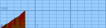
Each horizontal line is 100 feet. Each vertical
line is 0.2 miles. Gradiometer grade
(Grade linearly interpolated from gradiometer
samples, and smoothed with a 0.04mi gaussian.)
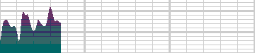
Each horizontal line is 2% grade. Each vertical
line is 0.2 miles. Altimeter grade
(Grade linearly interpolated from altimeter
samples, and smoothed with a 0.20mi gaussian.)
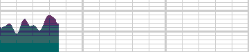
Each horizontal line is 2% grade. Each vertical
line is 0.2 miles. Comparison of grades
(Green grade is from the gradiometer, magenta grade
is from the altimeter, and white is where they
overlap.)
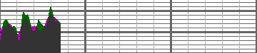
Each horizontal line is 2% grade. Each vertical
line is 0.2 miles.
Overall (averaging my first 20 hills),
the gradiometer grade averages 0.63 (% grade)
higher than the altimeter grade, with a standard
deviation of 4.5 (% grade per road).
This error may be due to:
-
Uneven sampling -- I take more samples when the
hill gets steep.
-
Calibration error (of the gradiometer or
altimeter).
In the end, though, I think that each individual
sample is accurate to within about 2% for that
instantaneous segment of road. My results may
not always agree with my altimeter, but they are
generally repeatable within 1%. I think that
I just need to take more samples to generate
more accurate graphs.
Raw Data:
Dist    Grade   Alti.   Location
----    -----   ------  --------
0.00     5%     440	start - Tripp Rd.
0.03    15%     460	430 Summit Springs
0.08    16%     490
0.12    12%     520	450
0.17    13%     560	460
0.20    10%     570
0.22     2%     570	before right turn
0.25    17%     590	470 (right turn)
0.26    20%     600	still right turn
0.27    21%     610	end of right turn
0.29    17%     620	start straightaway
0.32    19%     660	end straightaway
0.36    13%     680	after left bend
0.38    10%     690	at Patrol Road
0.42    11%     720	505
0.44    17%     740	right bend
0.47    14%     750	515
0.53    12%     780	entering steep left turn
0.56    17%     810	560
0.58    23%     830	555 (26% on inside of turn)
0.60    21%     850
0.62    18%     870	leaving left turn
0.64    14%     880	entering right turn
0.66    16%     910	595
0.71    14%     940	dead end
Back to
Lucas's
cycling gradiometer page.