Entire profile:
Description:
Mount Diablo is one of the most visible landmarks in the Bay Area. On a clear day from the summit, The sweeping 360-degree panoramic view allows you to see almost the entire Bay Area, as well as a good portion of the Central Valley. The climb itself is mostly moderate, with occasional steep turns and a final 150-yard stretch of straight 16% grade. The climb is mostly exposed, with breathtaking views, but does pass through several shaded groves with picnic areas and campgrounds.
Altimeter altitude
(Altitude linearly interpolated from altimeter samples, and smoothed with a 0.04mi gaussian.)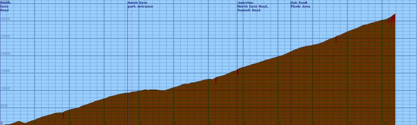
Each horizontal line is 100 feet. Each vertical line is 0.2 miles.
Gradiometer grade
(Grade linearly interpolated from gradiometer samples, and smoothed with a 0.04mi gaussian.)
Each horizontal line is 2% grade. Each vertical line is 0.2 miles.
Altimeter grade
(Grade linearly interpolated from altimeter samples, and smoothed with a 0.20mi gaussian.)
Each horizontal line is 2% grade. Each vertical line is 0.2 miles.
Comparison of grades
(Green grade is from the gradiometer, magenta grade is from the altimeter, and white is where they overlap.)
Each horizontal line is 2% grade. Each vertical line is 0.2 miles.
Overall (averaging my first 20 hills), the gradiometer grade averages 0.63 (% grade) higher than the altimeter grade, with a standard deviation of 4.5 (% grade per road). This error may be due to:
- Uneven sampling -- I take more samples when the hill gets steep.
- Calibration error (of the gradiometer or altimeter).
Raw Data:
Dist    Grade   Alti.   Location
----    -----   ------  --------
0.00	  4%	590	start - South Gate Road at Athenian School, 0.11 mi from Diablo Road
0.02	  0%	600
0.06	 -6%	600
0.09	  0%	590
0.13	  4%	600
0.16	  0%	610
0.21	  3%	610
0.27	  4%	615
0.32	  6%	630
0.38	  8%	650
0.44	  6%	670	Diablo Ranch Estates (being built)
0.48	  7%	690
0.51	  7%	705
0.54	  0%	710
0.56	 -8%	700
0.59	 -7%	690
0.62	-10%	680	rough road
0.64	 -6%	670
0.67	 -6%	660
0.71	  0%	650
0.73	  6%	650
0.77	  6%	660
0.80	  5%	680	end of potholes
0.83	  7%	690
0.86	 16%	700	sharp right turn
0.87	  8%	705
0.90	  6%	720
0.95	  6%	730
0.97	  9%	735	sweeping right turn
1.01	  6%	750
1.05	  7%	770	signs: emergency parking only, no scooters or skateboards
1.08	  8%	780	sign: speed limit 20, radar enforced
1.10	  3%	790
1.13	 15%	800	right turn, sign: fire danger today: XXX
1.14	  8%	805
1.16	  6%	810	sign: speed checked by radar
1.17	  3%	820	sign: no alcoholic beverages permitted in park
1.20	  7%	825	sign: (curvy) next 6 miles
1.23	  5%	840
1.32	  6%	860
1.36	 12%	875	middle of S-curve
1.38	  6%	880
1.49	  6%	910
1.53	  4%	930
1.55	  0%	930
1.59	  2%	940
1.66	  3%	950
1.70	  7%	950
1.73	  2%	950	sign: emergency parking only next 2.5 miles
1.77	  1%	960
1.79	 11%	940	right turn
1.81	  8%	960
1.84	  8%	980
1.88	  5%	1000
1.98	  7%	1030
2.03	  7%	1050
2.09	  4%	1060
2.13	  6%	1070
2.18	  4%	1080
2.24	  6%	1090
2.27	  8%	1100
2.31	 15%	1120	sharp right
2.32	  7%	1130
2.37	  7%	1150
2.39	  6%	1160
2.48	  6%	1180
2.52	 12%	1200	right turn
2.54	  5%	1210
2.57	 14%	1215	right turn
2.58	  3%	1225
2.61	  7%	1230
2.70	  6%	1260
2.73	 10%	1280	approaching left turn
2.75	  4%	1290
2.81	  5%	1300
2.85	  6%	1315
2.88	  8%	1320
2.91	  5%	1330
2.96	  4%	1350
3.02	  6%	1360
3.07	  7%	1380
3.13	  7%	1410
3.22	  7%	1430
3.26	  6%	1440
3.32	  5%	1455
3.41	  4%	1480
3.45	  2%	1490
3.51	  2%	1500
3.57	  4%	1510
3.58	 11%	1510	right turn
3.60	  1%	1520
3.67	  2%	1520	South Gate (kiosk, employee residence, stop sign)
3.75	  6%	1530
3.78	  2%	1545
3.84	  2%	1555
3.91	  3%	1555
3.96	  4%	1580
4.00	  0%	1580
4.05	  4%	1585
4.10	  4%	1600
4.12	  7%	1600	zig to the right
4.14	  3%	1610
4.19	  0%	1615	right side: vertical rock with hollows, carvings
4.21	-14%	1615	short drop
4.23	 -2%	1600	40-foot granite face on right
4.26	 -1%	1600
4.30	  3%	1615
4.34	  0%	1615
4.43	  0%	1615
4.49	  0%	1615	lower Rock City Picnic Area
4.56	 -2%	1600
4.65	 -1%	1590
4.68	  0%	1590
4.72	  7%	1590
4.76	  6%	1600
4.80	  3%	1615
4.87	  8%	1635
4.91	  5%	1650
4.96	  5%	1670
4.98	  1%	1670
5.02	  4%	1685
5.08	  6%	1700
5.11	 12%	1710	right turn
5.13	  6%	1720
5.18	  4%	1730
5.20	 15%	1745	right turn
5.22	  3%	1755
5.25	  3%	1765
5.31	  0%	1780	parking lot on right - mtn bikers
5.37	  0%	1780
5.41	  4%	1780
5.44	  6%	1790
5.49	  3%	1815
5.57	  2%	1820
5.61	  5%	1825	entering pine grove
5.68	  6%	1850
5.70	  2%	1850
5.77	  4%	1865
5.83	  7%	1880
5.87	  7%	1900
5.92	  1%	1905
6.01	  2%	1920
6.04	 -1%	1920
6.07	 -4%	1915
6.10	  0%	1905
6.12	  7%	1920	sign: elevation 2000 feet
6.15	  8%	1930
6.19	  8%	1950
6.23	  7%	1980
6.26	  3%	1980
6.29	  5%	1990
6.33	  7%	2000	entrance to Wildcat Group Camp
6.38	  5%	2015	sign: speed limit 15
6.44	  7%	2025
6.51	  4%	2060
6.57	  8%	2085
6.59	  7%	2095	sign: one-lane road
6.61	  9%	2105	stop sign: left lane ahead collapsed
6.64	  5%	2120	end of one-lane road
6.66	  7%	2130
6.70	  4%	2140
6.75	  7%	2160
6.78	  7%	2165
6.83	  9%	2190	junction with North Gate Road -- begin Summit Road
6.84	  9%	2200
6.87	 10%	2220	right turn
6.89	  5%	2230	entering grove
6.93	  6%	2240
6.98	  4%	2260
7.03	  8%	2265	picnic ground on right -- under oak shade
7.07	  4%	2285
7.13	  4%	2305	speed limit 20 -- radar enforced
7.18	  6%	2315
7.25	  6%	2345	mile post 7.1
7.30	  5%	2355
7.41	  5%	2385
7.44	  5%	2395	lookout point picnic area
7.51	  5%	2425
7.56	  7%	2435
7.63	  6%	2465
7.71	  6%	2480
7.77	  5%	2500
7.83	  6%	2520
7.94	  5%	2550
8.02	  6%	2580
8.09	  6%	2590
8.16	  6%	2620
8.20	  9%	2640
8.23	  9%	2645
8.25	 11%	2655
8.28	  9%	2675
8.31	  8%	2685
8.33	  8%	2695
8.36	  5%	2705	oak knoll picnic area
8.39	  8%	2725
8.42	  8%	2735
8.45	  7%	2755
8.51	  7%	2775
8.54	  5%	2785
8.56	 13%	2795	right turn
8.58	  9%	2800
8.61	  9%	2815
8.64	  7%	2825
8.70	  8%	2840
8.73	  4%	2850
8.79	  1%	2860
8.82	  4%	2870
8.91	  5%	2880
8.97	  2%	2890
8.99	  7%	2900
9.01	  2%	2910
9.07	  6%	2910
9.14	  4%	2930	sign: speed limit 15
9.18	  6%	2940	big paved parking lot on the left - westerly view
9.22	  8%	2960
9.28	  7%	2975
9.33	  6%	3000
9.37	  9%	3020
9.39	  8%	3030	mile post 9.25
9.43	  6%	3045
9.47	  8%	3070
9.52	 12%	3080	right turn
9.53	  6%	3090
9.59	  7%	3110
9.64	  8%	3125
9.68	  9%	3155
9.71	  8%	3165
9.75	  7%	3175
9.80	  6%	3195
9.86	  9%	3225
9.91	  6%	3245
9.95	  7%	3265
10.01	  7%	3295
10.07	  7%	3315
10.12	  7%	3335
10.18	  6%	3355
10.20	 10%	3365
10.23	  5%	3375
10.27	  7%	3385
10.32	  7%	3415
10.39	  7%	3445
10.43	  8%	3465
10.46	  3%	3475
10.51	  5%	3485
10.56	  7%	3490
10.58	  4%	3505
10.63	  7%	3515
10.67	  3%	3535
10.74	  3%	3545
10.78	  9%	3560
10.80	  4%	3570
10.82	  5%	3570	crosswalk
10.87	  7%	3580
10.91	  5%	3600
11.00	  6%	3620
11.06	  4%	3630	sign: detour ahead
11.16	  4%	3660	day-use parking entrance to the right
11.18	  8%	3680
11.20	 10%	3680
11.21	  6%	3700	road splits
11.23	 10%	3700
11.24	 14%	3700
11.25	 16%	3710
11.26	 16%	3720
11.28	 15%	3740
11.29	 15%	3750
11.30	 15%	3750
11.32	 16%	3770
11.33	 15%	3770
11.34	 15%	3780
11.35	 14%	3790
11.36	 13%	3800	sign: summit elevation 3849
11.37	  9%	3810	entering 20-min parking lot at the summit
Back to Lucas's cycling gradiometer page.