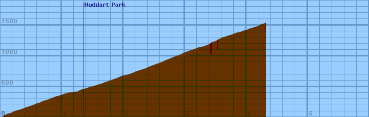
Starting at Greer Road, 0.1 mi and 20 feet above Tripp Road, Kings Mountain climbs through the redwoods of Huddart Park, up to Skyline. It offers plentiful shade, moderate grades, and occasional views. On weekdays, this can be a glorious climb, and a fun descent. On weekends the traffic can be annoying, but the scenery makes it worthwhile.
Overall (averaging my first 20 hills), the gradiometer grade averages 0.63 (% grade) higher than the altimeter grade, with a standard deviation of 4.5 (% grade per road). This error may be due to:
Dist    Grade   Alti.   Location
----    -----   ------  --------
0.00	 3%	450	Greer Road
0.01	 7%	450
0.04	 8%	460
0.06	10%	470
0.07	10%	480	Entrance Way
0.09	 8%	490
0.11	 7%	500
0.16	 5%	515
0.18	10%	520
0.20	 6%	530
0.23	 6%	545
0.26	 7%	555
0.32	 7%	570
0.38	 8%	590
0.41	 8%	605
0.48	 8%	625
0.52	10%	640
0.55	 8%	650
0.58	 7%	670
0.64	 7%	680
0.67	 8%	700
0.70	 5%	710
0.73	 8%	720
0.77	 7%	730
0.81	 7%	750
0.87	 7%	770
0.92	 6%	790	right turn -- crosses over the creek
0.96	 4%	795	wooden water tank
0.98	14%	810	short rise
1.00	 6%	810
1.03	10%	820	short rise
1.05	 6%	830
1.09	 3%	840
1.12	 1%	850
1.16	 3%	850
1.19	 5%	860
1.25	 6%	860	first view
1.30	 8%	890
1.33	 6%	900
1.36	 6%	905	Huddart Park entrance
1.39	 8%	915
1.43	 5%	930
1.45	 6%	935
1.52	 6%	955
1.58	 7%	970
1.62	 4%	990	10mph left switchback
1.64	 6%	990
1.69	 7%	1010
1.72	 8%	1020
1.76	 5%	1035
1.78	 7%	1040
1.83	 6%	1060
1.89	 7%	1080
1.94	 8%	1100
1.98	 6%	1120
2.02	 4%	1130	rocky stream (staircase-like) to the right
2.06	 6%	1135
2.11	 8%	1150
2.16	 8%	1170
2.18	 5%	1180	approaching 15 mph right switchback cut into hill
2.19	16%	1180
2.20	 8%	1190
2.23	 6%	1195
2.26	 6%	1210
2.29	10%	1215	short rise
2.30	 4%	1220
2.33	 6%	1230
2.38	 8%	1245
2.40	 9%	1260	right switchback over creek
2.41	 7%	1260
2.45	 6%	1280
2.51	 8%	1300
2.54	 7%	1315
2.57	 8%	1320
2.62	 9%	1340
2.66	 8%	1360
2.68	 6%	1370
2.71	 8%	1380
2.75	 6%	1395
2.79	 8%	1410	road widens
2.83	 7%	1430
2.93	 8%	1465	large turnout on left
3.00	 7%	1500	road narrows
3.03	 8%	1510
3.06	 6%	1520
3.08	 8%	1530
3.10	 6%	1535
3.12	10%	1540
3.14	 7%	1550
3.20	 6%	1570
3.21	13%	1580	15mph right switchback
3.23	 4%	1580
3.26	 5%	1590
3.28	 7%	1590
3.31	 7%	1600
3.34	 7%	1610
3.37	 8%	1620
3.41	 8%	1640	zig to left
3.42	 3%	1650
3.43	16%	1655	zag to right
3.44	11%	1670
3.46	 7%	1670
3.49	 7%	1680
3.52	10%	1690
3.54	 6%	1710
3.57	 7%	1720
3.59	12%	1730
3.61	 9%	1740
3.64	 9%	1750	left turn 15mph, gated dirt road off to right
3.67	 4%	1760
3.70	 9%	1770
3.73	 8%	1780
3.77	 7%	1790
3.84	 6%	1820
3.90	 6%	1830
3.98	 4%	1860	white-post fence on right
4.00	 6%	1860
4.05	 7%	1885
4.10	 7%	1900
4.15	 7%	1915
4.17	12%	1920	short rise
4.19	 4%	1930
4.23	 4%	1950
4.25	 7%	1960
4.28	 8%	1965
4.31	 9%	1975
4.32	 9%	1990	Skyline