Bunker Hill Drive, San Mateo map

Statistics:

Max. grade: 16%
Main climb:
Avg. grade: 9.0% (elev. gain/dist)
Length: 0.55 miles (0.88 km)
Elev. gain: 260 feet (79 m)
Entire profile:
Avg. grade: 6.2%
Length: 1.20 miles (1.93 km)
Climb: 260 feet (79 m)
Descent: 130 feet (40 m)

Description:

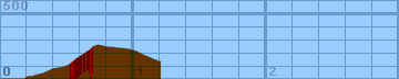
This hill starts at Polhemus Road in the unincorporated Crystal Springs area west of San Mateo. It starts out rather benign, gently climbing in fits and bursts. Most of the serious climbing is in the last few hundred yards, where it steadily rises at a 14-16% grade. Beyond the crest, it has a short drop, crosses over 280, and meets with Skyline Blvd.

Altimeter altitude

(Altitude linearly interpolated from altimeter samples, and smoothed with a 0.04mi gaussian.)

Each horizontal line is 100 feet. Each vertical line is 0.2 miles.

Gradiometer grade

(Grade linearly interpolated from gradiometer samples, and smoothed with a 0.04mi gaussian.)

Each horizontal line is 2% grade. Each vertical line is 0.2 miles.

Altimeter grade

(Grade linearly interpolated from altimeter samples, and smoothed with a 0.20mi gaussian.)

Each horizontal line is 2% grade. Each vertical line is 0.2 miles.

Comparison of grades

(Green grade is from the gradiometer, magenta grade is from the altimeter, and white is where they overlap.)

Each horizontal line is 2% grade. Each vertical line is 0.2 miles.

Overall (averaging my first 20 hills), the gradiometer grade averages 0.63 (% grade) higher than the altimeter grade, with a standard deviation of 4.5 (% grade per road). This error may be due to:

In the end, though, I think that each individual sample is accurate to within about 2% for that instantaneous segment of road. My results may not always agree with my altimeter, but they are generally repeatable within 1%. I think that I just need to take more samples to generate more accurate graphs.

Raw Data:

Dist    Grade   Alti.   Location
----    -----   ------  --------
0.00	 0%	 320	start - Polhemus Road
0.06	 0%	 320
0.14	 0%	 320
0.17	 3%	 320
0.18	14%	 320	right turn
0.20	 6%	 340
0.24	 1%	 340	Bennington Drive
0.27	 6%	 350	2168 Bunker Hill
0.31	 7%	 360
0.34	10%	 370
0.36	11%	 380
0.38	12%	 390	Oriskany Drive
0.40	10%	 400
0.42	 6%	 400
0.47	 5%	 410
0.50	11%	 420
0.52	15%	 430	2244 Bunker Hill
0.54	14%	 450	Lundys Lane
0.58	13%	 480
0.61	16%	 500	2268 (Middle of long straightaway)
0.64	15%	 520
0.67	15%	 540
0.69	15%	 560	right turn
0.71	13%	 570
0.73	 0%	 580	Yorktown Road (top of hill)
0.77	-6%	 570
0.81	-7%	 560
0.84	 0%	 560
0.92	 0%	 550
0.95	-5%	 550
1.02	-9%	 530
1.08	-7%	 500
1.15	-10%	 470	280 overpass
1.20	-10%	 450	end - Crystal Springs Road


Back to Lucas's cycling gradiometer page.