Entire profile:
Description:
This ride was my first day of spring break. I decided to go visit my brother in Calpoly. I took Foothill, Fremont, Hollenbeck, Stevens Creek, and Monterey to Gilroy. Then I hopped on Hwy 25 for 60 miles through Hollister and Pinnacles to Bitterwater. This section was fun. It was peaceful, isolated, beautiful, and somewhat hilly (mostly the last half). Then Bitterwater road took me over the ridge and down to King City. From there I took frontage roads & Hwy 101 to San Luis Obispo. Traffic was never a problem -- I was either on nearly-abandoned (and rough!) farm roads, or on the wide (10-15 feet) shoulder of 101. Actually, 101 was a lot of fun, with the draft of the big trucks pulling me along in the mid-20's. The only drawback was the sections with bumpy ridges every ~15 feet (to warn sleepy drivers that they've drifted onto the shoulder?), which rattled my bike so hard that my Avocet 50 died. The climb up Cuesta grade was fine (plenty of shoulder), and the trip down into SLO was a blast. The truck speed limit is 35, which meant I could easily pull into the slow lane and coast with the trucks.
Altimeter grade
(Grade linearly interpolated from altimeter samples, and smoothed with a 0.20mi gaussian.)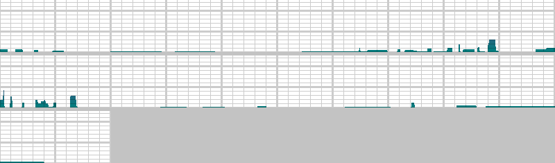
Each horizontal line is 2% grade. Each vertical line is 2.0 miles.
Altimeter altitude
(Altitude linearly interpolated from altimeter samples, and smoothed with a 0.04mi gaussian.)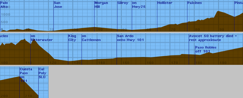
Each horizontal line is 100 feet. Each vertical line is 2.0 miles.
Raw Data:
Dist    Grade   Alti.   Location
----    -----   ------  --------
0.00	0%	  80	start - Rains Houses, Stanford, 12:15am
1.4	0%	 190	Page Mill Road (on Foothill Exprwy)
2.7	0%	 120	Arastradero Road
4.10	0%	 210	Edith Road 12:33am
6.12	0%	 220	Magdalena
6.87	0%	 260	Turning L onto Fremont
9.43	0%	 200	Turning R onto Hollenbeck (AVS 16.3mph)
11.5	0%	 290	Turning L onto Stevens Creek 1:02am
15.3	0%	 160	passing Saratoga Road
19.89	0%	 120	on Stevens Creek (San Carlos) @ Almaden Blvd
22.7	0%	 150	R on Market -> 1st, passing Tully, 1:39am, POTHOLE!
25.23	0%	 210	passing Skyway, AVS 17.3mph, 1:48am, better pavement
29.1	0%	 260	Bernal Rd, 2:00 am
31.5	0%	 280	Bait & Tackle Shop (on Monterey)
33.6	0%	 320	2:15am
34.46	0%	 330	3:01am, just fixed snakebite from pothole (690' sofar)
38.8	0%	 390	3:15am, AVS 17.3, Shell station in Morgan Hill (3:26)
48.3	0%	 250	3:53am, AVS 17.9, Shell statn, Leavesley, Gilroy (3:59)
51.10	0%	 240	4:09am, AVS 17.9, Nat'l 9 Inn, (760' sofar) -MMPE-
54.29	0%	 200	L on HWY 25 towards hollister
60.5	0%	 260	on HWY 25 - begin construction
61.7	0%	 290	end construction
64.7	0%	 330	Downtown hollister, AVS 17.4
64.9	0% 	 350	5:13am, 7-11 stop
66.2	0%	 370	5:20am, Burger King in south Hollister (5:40)
68.75	0%	 520	last stopsign outside hollister
69.8	0%	 570	Best road
71.6	0%	 570	Entering Tres Pinos 6:05am
72.2	0%	 610	leaving Tres Pinos
72.9	0%	 540	bottom of hill
74.4	0%	 630	cresting
75.1	0%	 660	another rise top
77.0	0%	 700	6:33am, Paicines minimart 6:30am-6:30pm weekdays, S/S 8:30am-6:30pm, (6:50am)
77.8	0%	 770	crest
78.1	0%	 740	low point
80.58	0%	 780	approaching hill
81.5	0%	 880	cresting
82.63	0%	 830	starting another hill
82.93	0%	 890	cresting
83.4	0%	 840	low point
85.5	0%	1000	7:31am
86.01	0%	 950	low point - bridge over San Benito River
86.41	0%	1000
87.35	0%	1020
87.90	0%	1010	begin big climb
88.09	0%	1050	7:50am (stop to take off layer of clothes) (7:56)
89.30	0%	1430	top of climb
89.85	0%	1450	begin descent
92.5	0%	1330
94.5	0%	1190	turn R on entrance to pinnacles 8:27, 2400' sofar
96.46	0%	1060	turn around, gravel wipeout, 2400' sofar, AVS 15.7 8:37 - store hours: M-F 4pm-5pm, S-S 9am-5pm
98.42	0%	1190	2540' sofar, from 142 R on 25, 9:07am "King City 25mi"
100.00	0%	1350	2710', 15.6mph, 9:15am
100.57	0%	1460
100.80	0%	1560	top of steep climb, 2910' sofar, nice pinnacles view
101.8	0%	1380	"25mi to King City"
102.2	0%	1490
104.0	0%	1500	finished going around lake
104.4	0%	1550	flattening
104.9	0%	1540	heading down
106.35	0%	1390
106.8	0%	1480
107.4	0%	1540
108.0	0%	1640
108.2	0%	1680
108.7	0%	1730
109.6	0%	1750
110.15	0%	1820	cresting
110.5	0%	1700	Coalinga Road 10:15am, cont. R on 25
112.62	0%	1460	Bitterwater. 10:23am, unmarked, houses, steep climb to right
113.7	0%	1780	was steep grind, beautiful view from here
114.0	0%	1790	going down
115.9	0%	1390	downhill -- hit 42mph coasting
118.25	0%	1060
120.1	0%	 830	flattening...?
122.3	0%	 470	dropping
128	0%	 330	King City, turn L on Metz.
128.85	0%	 330	on Metz
130.54	0%	 350	stopping at snackshop on Metz (12:23am)
133.6	0%	 420	on Cattlemen
136.5	0%	 410	"12 mi to San Ardo"
140.45	0%	 460	on Cattlemen
146.41	0%	 500	1:39pm, San Ardo
148.0	0%	 560	merging onto 101
153.9	0%	 580
158.9	0%	 600	2:26pm
162.1	0%	 580
170.35	0%	 710
174.1	0%	 730
174.7	0%	 800
177.7	0%	   ?	Avocet 50 died. about 4900' sofar
180.34	0%	 760	Paso Robles
182.25	0%	 730	River Road (south of Paso Robles)
184	0%	   ?	Dropped chain, smooshed small chainring
185.85	0%	 920
187.45	0%	 840	on El Pomar(?)
200.00	0%	   ?	5:59pm
208	0%	1520	Cuesta Pass (approximate distance)
215.76	0%	 250	7:18pm, at Pat's place, Calpoly, AVS 15.4, MXS 47, 15:57:48 riding time (elevation approximate)
Back to Lucas's cycling gradiometer page.